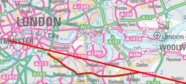
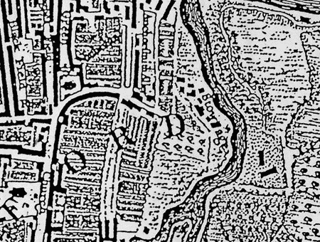
The top red line shows where the Roman road 'ought' to go, and if I am right,
where it actually does go (apart from a slight deviation to the south in the
Deptford and Greenwich area); the bottom line shows its present route.
I have found a method of finding Roman roads by using a form of 'field walking', that is, by checking for any unusual subsidence patterns that an object as massive as a Roman road might have generated.
This is not an entirely new method, it has long been recognised that in open countryside traces of Roman roads often remain, but it is generally assumed that it is not possible to find any traces in built-up urban areas. However, it would seem that even where areas were completely levelled during the urbanisation of London that under certain conditions further settling takes place leaving characteristic undulations, particularly on the kerbstones of pavements. Bizarrely the effect is strongest in the low walls often found around council estates.
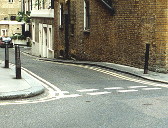
I drew a pencil line on a map of the theoretical alignment of the continuation of Watling Street and followed this as best I could to see if any traces were still remaining. Initially I did not expect to find much because South London is now heavily built-up. To my astonishment I found this strong and unusual subsidence pattern on a council estate just to the north of Elephant and Castle almost exactly where my pencil line had predicted it to be, and I knew I was on to something.
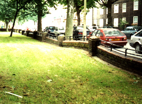
Falmouth Road, Rockingham Estate, SE1
In fact, these indications of what is almost certainly Watling Street occur along a considerable length of where the Roman road 'ought' to be, that is, following the straight alignment.
I found this particularly strong subsidence pattern over a mile to the east of Elephant and Castle in the oddly named Galleywall Road (this name has very obvious Roman connotations - a galley is a type of Roman ship). It is an almost identical feature to the Falmouth road one and probably represents the road having been 'robbed out', that is, its materials have been dug out for other building purposes.
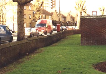
Galleywall Road, Bermondsey, SE16
The most curious thing about this original route is that after passing through Greenwich and Deptford it continues straight through South London to cross the Thames at Westminster. After this it almost certainly joined up with the North London Watling Street, the present Edgware road.
If my theory is correct then the original Watling Street was built to cross the existing crossing at Westminster (almost certainly a ford). It was never intended to cross at the London Bridge crossing as is usually assumed, and this raises questions as to why the Romans chose to make London their city and not Westminster. (see pre-Roman London and)
This is a transcription (merely changing the strange long 'S's with modern ones) of a document I found at the Guildhall Library in London (it was too old to photocopy) by checking a reference that the road had been seen in South London in the eighteenth century. It is part of a description of the route Watling Street took when it was still visible, before much of South London was built upon. This was written by the famous antiquarian William Stukeley (best known for his research on Stonehenge). He has followed Watling Street down from Warwickshire and this is how he describes the missing section.
William Stukeley 1722
Hence the road goes through Edgworth; and so at Paddington, by Tyburn, it crosses the other Roman road, called now Oxford-street, which was originally continued to Old-street, going north of London one way; the other way it proceeds by the back side of Kensington and through an unfrequented path, till it falls into the present Great road to Brentford, Stanes, &c. and it is a Roman road all the way, going pretty nearly east and west: therefore our Watling-street must cross it with an oblique angle; and by observation I found it to be about forty-five degrees. Higden takes notice that Watling-street ran to the west of Westminster over the Thames, so through the middle of Kent: from Tyburn I judge it goes over part of Hyde park,* and by May-fair, through St. Jamess park to the street by old Palace-yard called Wool-stable, to the Thames, here has been an old gate; one arch left but not Roman. On the opposite side of the river is Stan-gate ferry, which is the continuation of this street to Canterbury, and so to the three famous sea-ports, Rupiudae, Dubris and Lemanis. This Oxford road was originally carried north of London, in order to pass into Essex, because London then was not considerable; but in a little time became well nigh lost; and Holborn was struck out from it, as conducting travellers thither, directly entering the city at Newgate, originally called Chamberlains gate, and so to London-stone, the lapis millitaris from which distances are recorded: and hence the reason why the name of Watling-street is still preserved in the city, though the real Watling-street goes through no part of it, but through Southwark; or if we please, we may call this a vicinal branch of the Watling street.
According to method I should speak of Londinium here: but because the great deal that may be said thereupon will make a discourse by itself, we contend ourselves at present with giving a plan of it, as we suppose it might appear in the times of the Romans; and so continuing our tour into Kent, will finish the whole continuation of Watling street with what few memoirs I could pick up at that time.
As Old-street went on the north of London, so the proper Watling-street we have been upon, since High-cross in Warwickshire, went on the south; from Stan-gate ferry across St. Georges fields, so south of the Lock hospital to Deptford and Black heath: a small portion of the ancient way pointing to Westminster Abbey is now the common road on this side the nearest turnpike; but the continuation of it is quite lost since the bridge was made, and all roads meet at that centre as so many radii when London became considerable, the ferry over-against it, from being better attended, rendered that at Stan-gate almost useless; so passengers went through the city by Canon-street, Watling-street, and Holborn; hence so little appears of it between Tyburn and the Lock hospital; and probably its materials were long since wholly dug away to mend the highways. Upon this way in Southwark many Roman antiquities have been found, particularly a Janus of stone, in possession of Dr. Woodward: but our business shall be to prosecute the end of the second journey and the whole third and fourth of Antininus.
From Shooters hill the direction of the road, very plain both ways; a mile westward from the bottom of the hill you find vestiges of it just upon the common: some part of the agger is left, made of gravel near at hand: from the top of Shooters hill you see it butts upon Westminster abbey, where it passes the Thames; and this demonstrates its original direction, and that it was begun from the east; for the turn of the river at Greenwich intercepts it, though not observed in maps: so the way is forced to deflect a little southward there, and then recovers its point: beyond that hill it is very straight as far as the Ken reaches. On Black heath a vast tumulus, now used as a butt for archers, hereabouts in great request till Henry the VIIIths time and hence the name of Shooters hill.
*A brass Roman lar dug up about Grosvenor square (in possession of Mr Benpre Bell) near where the Roman road ran the Watling street.
Notes
Lock Hospital
was closed in 1760. The site is now covered by the junction of Tabard Street
and Great Dover Street.
Vicinal: neighbouring, adjacent, local.
This description of the route fits perfectly with my model and was able to explain why I had been unable to trace the road in the Greenwich area. However, since knowing that it deviated south I have found two more indications of it in Greenwich and at Deptford and it does indeed deviate to the south and crossed Deptford Creek to the north of the present Creek Road, SE8.
I have also been trying to find out where it went north of the Thames, this has always been a mystery as all traces of it are supposed to have vanished at Marble Arch, where the Edgware Road meets the roman Oxford Street. However by extending the alignment of Edgware road and searching along this imaginary line I have been able to practically 'see' it running parallel and slightly to the east of Park Lane under the streets of present-day Mayfair (see photo). I can't believe how anyone could have missed something so obvious, it also confirms Stukeley's observations.
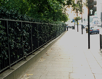
This is
looking down Brick street from Down Street, W1
This is
another view.
I have been looking for evidence of exactly how the two roads originally joined but ironically, the method I am using works best in built-up areas. However the railings between Piccadilly and Green Park are distorted where the road would be expected to be and although the effect is subtle it nevertheless suggests that the road continued into Green Park.
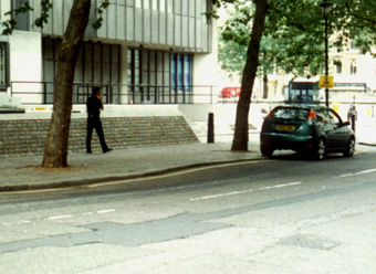
Piccadilly.
I have found possible indications of the road in St James's Park although they are too faint to be totally reliable.
Possible traces of Stukeley's road, however, can still be seen near Westminster Abbey.
Storey's
Gate, SW1
Im still not sure of the exact details of how Watling Street crossed the Thames at Westminster but I now think that the Westminster ford was purpose built for Watling Street in order to keep the road as straight as possible - to preserve the alignment.
Watling Street in the Greenwich areaProbably the most compelling piece of evidence for the existence of a straight Watling Street in South London is the Old Dover Road, SE3. I was born near here and I have always assumed it to be Roman but apparently it is not universally believed to be part of Watling Street. I was told by the Greenwich local studies library that once a Royal Commission had been set up to look into the origins of this humble little road and they decided that it wasnt Roman*, but many people do think that it is Roman these days including Channel 4's Time Team.
*Actually they may have been more correct than they realised, see Pre-Roman 'Roman' Roads
Watling Street in north Kent is remarkable for being exceptionally straight, like many, but by no means all Roman roads and follows a series of unusually long uninterrupted straight alignments. What is remarkable is how few of these alignments have been used in this stretch of Watling Street, far fewer than is typical for a Roman road in Britain, or indeed practical. Initially I guessed that the reason for this would have been to impress either foreign visitors as they arrived in Britain, or, as it was likely to have been the first (or one of the first) long straight Roman roads to be built - to impress the natives a type of showing off perhaps. But even if this is fancyful its extreme straightness should make it easy to follow and if it deviated at all it would have to be for a good reason.
The final alignment before it reached the London area starts near Spring Head, Swanscombe Park, Kent best known now for the Bluewater shopping centre near by and continued in a virtually perfect straight line untill the east of Greenwich, deviating only very slightly when fording rivers at Dartford and Crayford. However, as it reaches Greenwich it does something remarkable, it veers sharply to the south west to cross Blackheath. Although this road appears straight this is a modern rebuilding, the old maps show it crossing the heath in a distinctly winding way, and follows the parish boundaries, usually a good indicator of Roman roads, which show it to have been build in a series of short but straight alignments, quite different from the rest of Watling Street. However, I have no doubt that this road is Roman as it was still visible in the eighteenth century, but it is not, I believe, the earliest version of the road.
The Old Dover Road is a small stump of a road, less than a mile long, situated to the east of Greenwich Park, it clearly continues the original alignment of Watling Street for almost another mile. It is rumoured that in the late 1960s when the Blackwall Tunnel approach road was being excavated, amateur archaeologists found the remains of the original Watling Street even further to the west, nearer London, although so far, I have not been able to trace them or their findings. This road is so obviously part of Watling Street it is difficult to believe anyone could think otherwise.
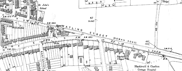
This is a close-up of the Old Dover Road (top left) where it
meets Shooters Hill Road forming a convincing straight section with Watling
Street. On this map of 1894 it is even called Watling Street, this is a close-up
for clarity, the continuous alignment is even more obvious on a larger map.
The road would have continued into Greenwich Park to directly pass the remains of the Roman temple (as featured on Time Team), just to its north and is probably represented by a V shaped notch at the edge of the temple site. This notch is probably modern as the park was formally and extensively landscaped in the 17th century and straight avenues were built obliterating any features, although intriguingly the avenue in this part of the park seems to have stopped at the temple site so the notch could be original (although it doesn't seem wide enough) or it may have been cut in the early 20th century at the same time as the temple was discovered in what might have been an attempt to find the missing road.
I believe the reason for a temple being here is undoubtedly because of the amazing view over the London area, the view is somewhat spoilt now as trees have been allowed to grown up, but in Roman times it could have had a view very similar to the one today slightly further along, at Wolfes statue, overlooking the Queen's House. However, if the road is confirmed as being here this effectively makes the temple a roadside shrine, and it would also have looked very dramatic from the road.
The descent down the hill at Greenwich at this point is remarkably even and gentle and is well chosen as parts of the hill at Greenwich are precipitously steep. The road at this point is no longer following the true alignment but is a slight detour to the south, just as Stukeley observed, and this would give the builders a certain amount of latitude about where the road could best be sited.
Continuing down from the temple site, the road passes to the right of what is probably a natural gully and it is here that the gravel surface of the road (if I am correct) is visible. Although there is no trace of an agger here (the typical ridge-like appearance of a Roman road) there is evidence that this part of the park has been landscaped and it is likely that the original road had been buried. However, a natural path has developed and for a considerable length the grass has worn through showing fine gravel over a very compacted layer of courser gravel and stones (this may only recently happened due to the dry summers we have been having). I have shown a colleague who has had experience digging Roman roads, he said it was a typical Roman road surface, however without being able to see the compete agger he was unable to confirm that it was indeed Roman. He did agree, however, that because there was a piece of red sandstone firmly embedded in it, which is not a locally occurring stone, then it must be man-made. He also confirmed that there was another probable Roman road, this time with the agger complete, in another part of the park and although this is aligned in completely the wrong direction to be Watling Street it may have something to do with the suspected Roman fort near by.
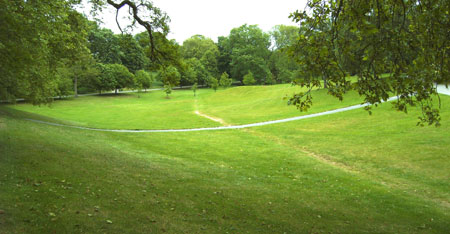
This is the view from the bottom of the hill looking up towards
the Roman Temple,
the exposed gravel is directly in the centre of the photo.
The road would have then crossed the lawn diagonally in front of the Queens House, a modern path representing the route. This is supposed historically to be the site of the road see...
You have to 'mouseover' the correct part of the image so I have included the text below
Western
avenue
From the base of Observatory Hill an avenue of trees leads down towards the
walled road, with a parallel (western) avenue in the distance. Between the
avenues, to the left of the Queen's House, is a path crossing the Park's lower
parterre (ornamental flower garden). It is the former Roman road to London.
In the 1660s the parterre was levelled from the Queens House up to the hill,
in preparation for a formal (garden) that was never built.
I havent yet found out who wrote this even though I have contacted the Museum but I suspect that it is Clive Aslet who wrote a book about the history of Greenwich and also believes the road was originally straight.
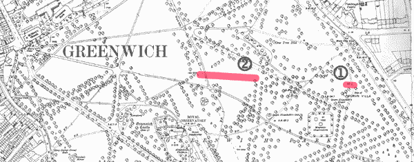
This is a map of Greenwich Park, the red dash, 1,
is the notch by the side of the temple,
2, is where the gravel surface is exposed. The way down from the
notch to the bottom of the hill on this angle is remarkably even, it would
then continue to where the modern park gate is to the left of the 'G' for
GREENWICH. Below the 'G' is a modern path but probably represents the course
of the path that is reputed to be the road in the painting 'The view of Greenwich
from One Tree Hill', see the link above.
It would then have continued to the Spread Eagle Tavern and probably went under its yard. At the back of the yard on the other side of the wall is now a modern car park and small business centre. Here there is one of these strange mounds more pronounced than any I have found and although it does not photograph well, it would not look out of place in a skate boarding park. It is possible, however, that another reason for it being there is that the entrance to this yard is a gap where a building used to be and the mound could simply be something to do with its basement foundations. Nevertheless, if my theory is right, the road would have had to come through this area.
From my research it seems Stukeley must have been fairly widely read in his day and it is perhaps significant that the Spread Eagle changed its name from the Eagle, a name already alluding to the Romans, to the much more Roman, Spread Eagle the symbol of the Roman Empire, in recognition of Stukeleys account. Stukeley became discredited after his death due to a copy of a Roman map of Britain which is now thought to have been a fake, but I have found no evidence that anyone ever questioned his archaeological observations and recently, time after time, in archaeological digs, he has been entirely vindicated, and the eighteenth century owner of the Spread Eagle presumably thought so too.
It would then have passed St Alphages church, possibly under it (there is
a myth that the Church was founded on the site of St Alphage's martyrdom and
I like to think he was standing on the remains of this road at the time),
and onto Deptford Creek. There is no doubt that the original Watling Street
would have had to have crossed the Ravensbourne river (a very minor tributary
of the Thames) somewhere, and if the proper alignment had been followed it
would have the crossed almost at the mouth of the river at Millennium Wharf,
but where I think the road crossed is further inland.
I think it is worth mentioning here that from my observations there seem to be two phases of Roman road construction, in the first phase the roads were, where possible, exceptionally straight and fords were generally used, later on the roads were far less straight being composed of many more alignments and rivers were generally crossed by bridge. I believe that the original Watling Street crossed the Ravensbourne, (known as Deptford Creek as it approaches the Thames), by ford, between the modern Creek Road bridge and the Laban Centre.
This would have been the deep ford - hence Deptford. There are a number
of mounds on ether side of the Creek where mud has built up and they may represent
some obstacle beneath, like a long abandoned wreck or they might have just
developed naturally, but there is the only one place where they occur on both
banks of the Creek simultaneously. In addition, there is a big change in the
nature of the rivers bed which happens exactly at this point in the Creek
and this is best observed at exceptionally low tides. This may be a natural
phenomenon, but there is, in effect, a weir at this point, everything further
upstream of this point is shallow, too shallow for boats at low tide, whereas
downstream it has been dredged and can use by boats even at low tide. If the
ford was at this point it would be hard and compacted and very difficult to
dredge and this would explain why this change takes place here.
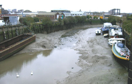
This photo is facing south up the Creek at an exceptionally low tide, in the
middle
is some rough water which is where I believe the ford to be, below this it
is smooth and deep.
Notice how the boats are taking advantage of these mounds for mooring.
There is an organisation called the Creekside Centre, an educational centre who organise visits to the Creek at low tide, they supply waders and other equipment. Due the Centre I have been able to visit the site and it is very obvious how easy it would have been to have crossed the Creek at low tide, as it still is, but there is no doubt that a causeway would have been needed to get through the marshy edges of the Creek. The gloopy mud that lines the edges of the Creek today would have been around then too, washed down from the continuous erosion of the Norfolk coast and deposited by the sea at every high tide. Indeed it is this mud that makes up all the low lying areas of London, the former marshes, and I am not in the least bit surprised having seen the softness of this mud that my subsidence method for detecting Roman roads works in these areas.
This part of the Creek is today exceptional tidal, the Creekside Centre have estimated that if you tried to cross at this point today and you missed the tide you would have to wait up to six hours for the next chance to cross it, however, the river Thames was lower then, possibly 15 feet lower so it might have been possible to wade through even at high tide.
Unfortunately this mud, including the inevitable shopping trolleys, conceals the two mounds that I believe are the remains of the ford and as yet I have not had a chance to excavate them.
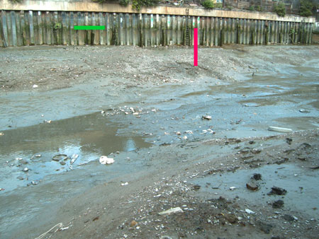
The ford is likely to lie in the centre of this photo where the water is disturbed,
the green bar represents the current high water mark and the red bar shows
how much lower the water might have been in Roman times (approx. 15 feet/4.5m)
Fortunately, Lewisham Council commissioned an extensive archaeological study of the Creekside area and there are some very strong indications of the road contained in the report. On the east bank there is what is considered to be a possible gravel island but it could of course be the metaling of the road. But on the west bank the report states that at this point there was a natural promontory jutting out into the creek, an obvious place to build a ford. More importantly, a clearly ancient road now called Stowage, SE16, almost certainly represents the course of the road. Its first recorded name was Greenstreet, a classic indicator of a Roman road, later it was also know as the 'Lynch' which meant bank or ridge, a good description of how an agger would have looked. Near here is a marsh called Sabine marsh, I dont know if this is significant but Sabine is a Roman word.
This eighteenth century map shows the road Stowage
running down to the Creek, under the letter 'D' of FORD.
The medieval church of St Nicolas is built either directly on, or just to the south of, the proposed Watling Street. The 13th century tower is built of stone, and whatever else was to hand, and it is clear that it would have originally have been faced with flints and so the stonework would not have originally been visible. Included in the structure are various bits of red tile and it is possible that these are Roman, Im sure an expert would be able to decide, however, even if this were so it would, of course, prove nothing as it is known that there were Romans in this area.
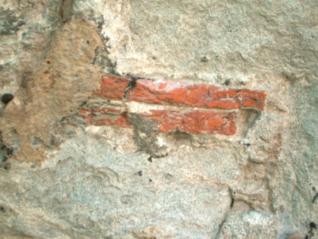
possible Roman tiles in St Nicolas Church tower Deptford
To the west of the Creek the road is lost again although there are various of the strange subsidence humps but nothing definite .
There is however the evidence of the place-names - to the west of the Creek is a Street Farm and Street Lane, again classic indicators of a Roman road.
There is however an other indication - the place-name 'Halfway House'. On Roques map of London here are several Halfway Houses, hamlets appearing on main roads, mainly known Roman roads, and might indicate the Roman equivalent of a service station halfway along a stage (six roman miles, roughly six modern miles). The Halfway House occurs in the right place halfway between London and Greenwich approximately six miles apart so surely London to Greenwich must be a Roman stage? Due to its proximity to the Old Kent Road it could be argued that it originally served the Old Kent Road, except there is a map where there are two Halfway Houses shown, each in the right place to serve its respective road. It could also be argued that halfway House does not sound Roman but then neither does the Old Kent Road (before that Kentish Street) yet it is. The Old Kent Road is definitely Roman and dated circa 100 AD, but as the Romans invaded in 43 AD how on Earth did they get about in this area before this road was built?
In May 2004 I got permission to dig a test pit at the Rockingham estate in Falmouth Road to find out what was causing these strange subsidence humps, I decided to dig the most obvious one. Access was limited due to a thin layer of modern concrete just under the surface, far too thin to be the cause of the mound. Beneath this was an open crack in the soil showing that this disturbance was still active. I was able to dig five feet down to a very hard layer of flints compacted into sandy clay. I am no expert but it certainly could have been the surface of a Roman road and was very similar to the gravel surface in Greenwich Park.
Having spent some time on the site I noticed that there was what looked like another buried road in the estate and was clearly visible, especially seen from ground level. This road can be identified on old maps of the area as a relatively recent road or path on what had been St Georges Common before being built on. This shows that, if this is correct, then under certain conditions subsidence really can show up massive objects buried under the ground. I also realised that on these early maps of the area, that although they didnt show the original Watling Street nor did they show Tabard Street and yet this street went on to become a proper residential street so there must have been substantial remains of it then but the map makers chose to ignore it.
I should also add that most of the archeologists I have contacted believe that it would have been impossible for the Romans to have built a road here due to something called the 'Rockingham anomaly', a particularly marshy area, however, this area is like a small valley with a natural bank at on end blocking it but the road runs along the side of the valley missing the deepest, and therefore, marshiest section.
home
| missing Roman road | The
real Troy discovered | pre-Roman London
| Britain's forbidden history | contact
the author