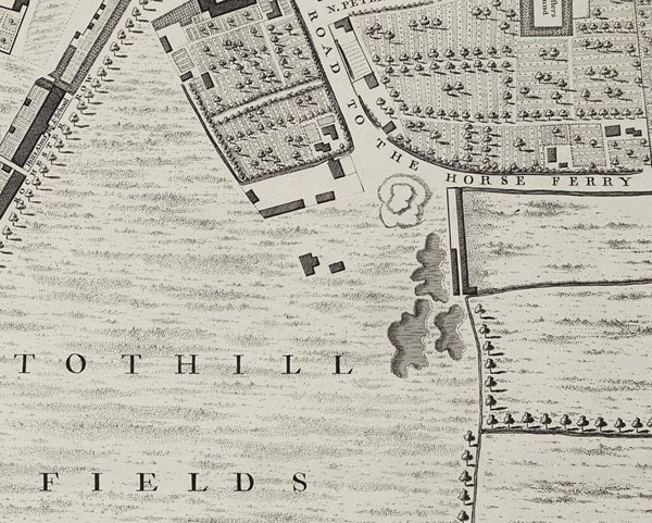
Recently I went to look for the Tothill, an old ‘toot hill’ or artificial mound that was supposed to lie near to the bend in Horse Ferry Road, Westminster, London. I had found the Rocque map, which was supposed to show the mound. There was something marked in the right spot but it needed to be checked, as it could have been some kind of pit/pond etc.
Rocque's map, circa
1746
It was supposed to be completely lost - but there it was, now just a small rise in the general ground level - but a rise nonetheless and evidence of the remains of the mound, near the point where the modern roads Maunsel Street and Regency Street meet.
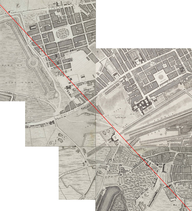
I am not the first to have discovered the Tothill but I think I am the first to work out its significance. What is remarkable about it is that it is in a perfect alignment with the last section of the ‘north London’ Watling Street (although this is not officially recognised).
 Roque's
map with alignment
Roque's
map with alignment
At the ridge near Maida Vale, where the modern roads, Maida Vale and Edgware Road, meet, there is a slight change in alignment to the east, of this the final section of Watling Street before it crossed the Thames. From this new alignment, the road was all downhill with the Tothill its final point.
I believe that what the Tothill represents is a terminus of the north London section of Watling Street, in exactly the same way as the Victorian railway lines had their terminuses (if that is the correct expression) such as Victoria, Kings Cross, Charing Cross, etc. Just like the Victorian termini, the Tothill seems to have been built on the outskirts of the then existent Westminster. The road probably split before it got to the Tothill with some travellers going to the horse ferry and others using the ford. It should be remembered that the ford would not have been crossable except at low tide, which could have been a long wait, although the rich and those in a hurry would have used the horse ferry, which no doubt would have required a toll or charge. It is not clear if the name refers to the ferry being powered by horses or it being large enough to carry horses, certainly to be of any use it would have needed to have carried the travellers, their vehicles (chariots at the very least) and their horses.
The other travelers would have crossed by the ford. It would have been impossible to have built a crossable ford that spanned the river in the London area when the tide was in - it would have been far too big (the first ford to be able to do that, non-tidal, would have been a lot furter inland, probably at Kew), besides which it would block the river for shipping. However, as can be seen at Creekside in Deptford, at low tide a ford could have been relatively easily constructed, indeed there are supposed to be the remains of at least seven fords across the Thames in the London area.
It would however have been a very muddy affair with fresh silt being deposited with every new tide. It seems more likely that crossings were made in horse drawn vehicles. I have seen footage of a modern ford in Afghanistan where a huge wagon (much like the haywain in the John Constable painting of that name) drove through the ford. Clinging to its sides were many foot travellers similar to people in India travelling on the outside of trains.
It is very difficult to imagine the Romans putting up with this, they would simply have built a bridge, something that they certainly had the skills to do, nor would they have built a mound, a round one at that, it is totally out of character, so it does look very much like Watling Street was built by the Ancient British as the old British histories tell us, see, Who built the British Roman roads?
Apparently there would have been around a six hour wait if you had just missed
the tide but there would have been plenty to do, the Tothill as its name implies
was a toot hill, a lookout point, so no doubt some travellers would have climbed
it to get the ‘lie of the land’, to work out where they had to
get to next. The area to the west of it was known as Tothill Fields, Vincent
Square is its remains, this is where the medieval jousting took place, but
long before this the mysterious ‘Game of Troy’ a game played on
horseback with the riders wearing the gold torques that so often turn up in
archaeological digs, was supposed to have been played, it was also a game
played by the Romans.
Nearby would have been
the May fair, hence Mayfair, a fair held from the first of May (May Day) which
was the beginning of the travelling season for ordinary people. Travellers
could visit the Temple of Apollo at the site of
Westminster Abbey and listen to the singing of hymns accompanied by Welsh
harps. Or, if the wait was too long, perhaps a quick trip up the Strand to
visit Trinovantum, as London was then known, for a spot of shopping before
perhaps crossing at the ford at the London Bridge site and continuing one’s
journey that way once the tide had gone down.
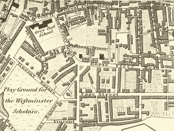
Westminster 1827
home
| missing Roman road | The
real Troy discovered | pre-Roman London
| Britain's forbidden history | contact
the author