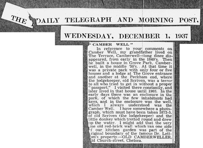
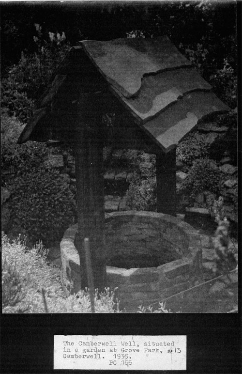
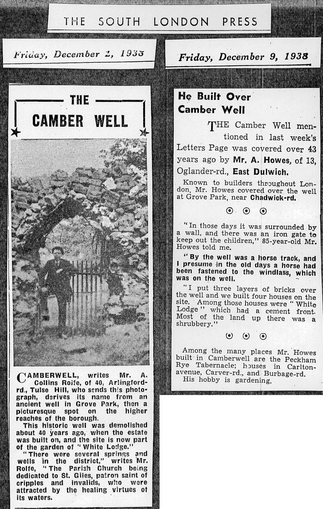
It has long been noted that Camberwell, like many other districts in London, is named after a well. In the case of Camberwell tradition has it that the original well was in Grove Park, off Camberwell Grove.
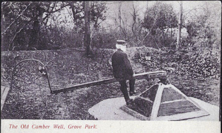
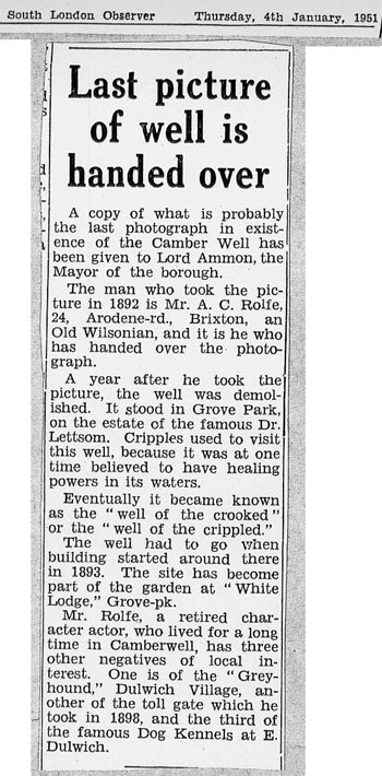
This photo of the well is thought to have been taken in 1892
shortly before it was ‘demolished’. It is not clear when it was
captioned but notice how 'Camber' and 'Well' are separate words.
This seems to be the original untouched-up photo (note the
twigs and branches in the foreground). The well is in a dip and surrounded
by earthen banks, the photo seems to have been taken from on top of one of
these banks. In the middle of the well is what is described as a pump on the
Ordinance Survey map of 1868 and was powered, via the arm, by a donkey, the
harness can be seen at the end of this arm. There is a circular track visible
in the photo which seems to be made of compacted stones or chalk and although
it looks like it could be ancient it is more likely to be contemporary with
this, or an earlier, animal powered pump.
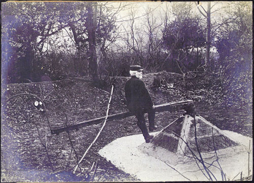
It is clear that at the time of the picture, which is supposed to have been a year before the well was demolished, that the site has been tidied up - notice the freshly cut wood, presumably it had been allowed to become overgrown - indeed it was described as a shrubbery just before the new houses were built on the site. It is not unreasonable to assume therefore, that this photo was taken by some of the people who were known to be trying to save the well. The area around the pump has been recently re-laid; you can see fresh crumbs of soil on it and it is just possible that this had been done by the builder of the subsequent houses, as it is said that he was also sympathetic about saving the well.
The man in the photo might be Old Scriven the lodge keeper of Grove Park, although it is impossible to be sure.
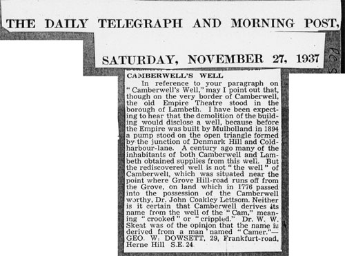
Although there must have been many wells in Camberwell, Wells Street is named after some; all the authorities seem to agree that the original ancient well is the one in the photos above.
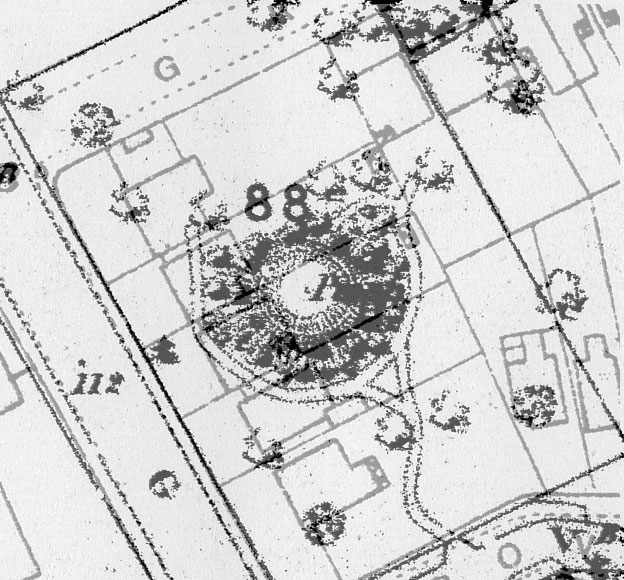
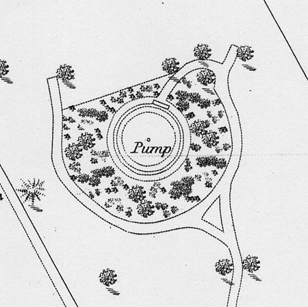
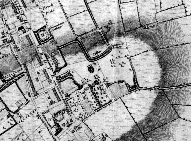
Here it is on the Ordinance Survey map of 1868
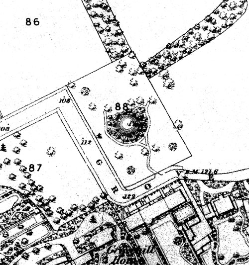
The lettering by the well says Pump, it is far clearer on the
original map, this is a scan of a photocopy.
It is a very strange shape and like no other well in the area. The actual well is in the centre of a large bowl-like shape. Actually it seems to have been originally a round structure like a ring doughnut, the straight bank at the north seems to have been part of a later, rectangular reservoir (?) or bath house which can be seen in the earliest maps, it would have been in the right place as it is the most downhill part of the site.
In the nineteenth century this bowl shape was known as the ‘Enclosure’, in the eighteenth the ‘Bason’ = basin. It is clearly an ancient structure; Roman coins were reputed to have been found at the bottom of the well, which if true, means that the well is at least 2,000 years old, see excerpt from ‘Old Camberwell’ below.
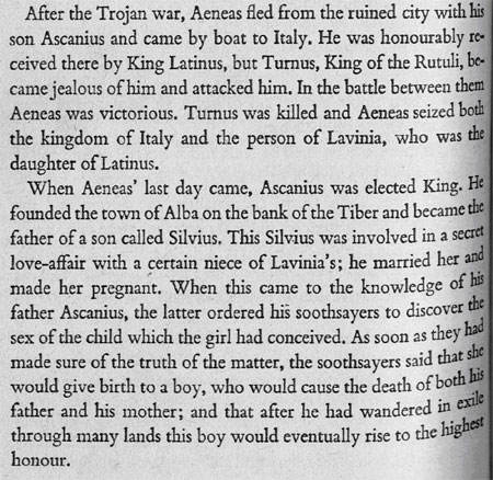
Here is some of the early history and theories on the origin of the place-name 'Camberwell' according to local historian Blanche in the Victorian period.
(the suffix ‘ville’ seems unlikely - as modern
research has shown that, at least in the London area, the suffix ‘well’
simply meant a well, although probably in every case an old or ancient well).
Of all the theories I prefer the Prince Camber one, even though it is clear that it is not being advanced as a serious theory in this book. It should be pointed out that this book was written at a time when the existence of Troy was not believed. Schliemann, I hope, has proved that Troy existed (there is a certain doubt as to which layer represents the Homer's Troy but I don't think there are any experts who would doubt its existence).
However, strange as it may seem, it does appear that London had already existed as an important city long before the Romans came to Britain and the idea that London was founded by the Romans is a relatively recent idea. Had the Romans founded London it is highly likely they would have mentioned this. In fact the Roman accounts can only be explained if London already existed - for instance London was famous, even to the Romans, for the wide variety of goods that could be bought there. It was also described as an ancient Iron Age hill fort, i.e. pre-Roman and there are many discrepancies in the description of London during Bouddica's uprising that can only be explained if London was already an established city.
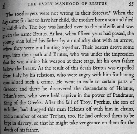
During the Middle Ages (and earlier) all the historians who dealt with this particular time, the pre-Roman period, all agreed that London was pre-Roman and had been founded by a Trojan - Prince Brutus, around 3000 years ago, long before the Roman period. It is of course possible that they were all making it up - 'monkish fables' - but this seems highly unlikely as Brutus is mentioned in numerous histories. Crucially for the history of the well Brutus had three sons, one named Camber, who could have had the well built, or was perhaps built in his memory - he would have been a famous war hero, (see below). There is further evidence of Trojan influence nearby in Peckham, the modern street name Troy Town, SE15 is said to be named after a turf cut maze that used to exist there which celebrated the ancient ‘Walls of Troy’ and these were, apparently, quite common.
This is one account of Prince Brutus
This is perhaps the fullest
account of Prince Camber, spelt here with a ‘K’ and is given by
Geoffrey of Monmouth; other accounts have the three brothers named after
the existing names for the countries or kingdoms in Britain at this time.
But why Camberwell?, because if London was founded in the Late Bronze Age period and given all the evidence this shouldn't be dismissed too lightly, then it would have needed some good reliable roads. Perhaps the most crucial would have been the one that would have linked the new city with what is now south London and it would have needed to have crossed the marshy low lands - not impossible at the time but certainly difficult and the shortest route would have been towards Camberwell, Camberwell being the nearest high ground to the south of this early London.
This road, represented by the modern Walworth Road and Camberwell Road, is a causeway (raised up), which strongly suggests that it was built before the marshes were fully drained, and could easily suggest a pre-Roman date. When its continuation to the south, Denmark Hill SE5, was examined in Victorian times, when sewers were being laid, the original road was found and it was reported that it was built of stone with curbs made of wattle, which apparently is typically pre-Roman the Romans used curbs of stone.
But even if none of these early histories are true it is clear that they were believed as if they were true and were regarded as real. To give an example, whoever decided that St Giles should be the patron saint of Camberwell ( the Normans?) seems to have been aware of the myth of Prince Brutus.
This also from Geoffrey
of Monmouth
Which has some parallels with the story of St Giles
from Wikipedia
As
a hermit Giles first lived in retreats near the mouth of the Rhône and
by the River Gard, in Septimania, today's southern France. The story that
he was the son of King Theodore and Queen Pelagia of Athens is probably an
embellishment of his early hagiographers; it was given wide currency in Legenda
Aurea.
His
early history, as given in Legenda Aurea, links him with Arles, but finally
he withdrew deep into the forest near Nîmes, where in the greatest solitude
he spent many years, his sole companion being a deer, or hind, who in some
stories sustained him on her milk. This last retreat was finally discovered
by the king's hunters, who had pursued the hind to its place of refuge. An
arrow shot at the deer wounded the saint instead, who afterwards became a
patron of cripples. The king, who by legend was Wamba, an anachronistic Visigoth,
but who must have been (at least in the original story) a Frank due to the
historical setting, conceived a high esteem for the hermit, whose humility
rejected all honors save some disciples, and built him a monastery in his
valley, Saint-Gilles-du-Gard, which he placed under the Benedictine rule.
Here Giles died in the early part of the eighth century, with the highest
repute for sanctity and miracles.
I don't want to suggest
that It was a hunting accident involving a deer, also during this early French
period most of the French kings were considered to have been descended from
Trojans, especially the Franks and it is likely this would have been believed
at the time so it is possible that when a saint was chosen from the many alternatives
available, the best possible fit was chosen according to what was known about
the history of Camberwell at that time.
The well certainly seems to be ancient but what is very odd is the structure around the well shaft; not only is it huge but it seems to have originally been circular and could easily be Bronze Age in date which is the right sort of age for Prince Camber. Indeed, it is like an inverted mound or tumulus and is a massive earthwork, which would have required a lot of digging, far more than would be needed for a normal well – it is clearly making a statement in the landscape. I would not be surprised if originally there had been a circular ditch surrounding it.
This gives an idea
of the size of the surround – the width of three large detached houses.
The well is said to be sacred, a holy well, and probably was right from its inception, and had it been built in pre-Roman times it might be considered to be a 'Celtic' equivalent to the Roman temple remains at Greenwich Park which I believe was probably located where it was for the outstanding views it had across the Thames (this view has now been spoilt by trees but would have had virtually the same view as that from Wolfe's Statue).
And this is just like
the ‘Camber well’ it would also have had commanding views (over
the fledgling London perhaps?) before the area was built up. A similar view
can still be had if you go to the end of the service road for the modern flats,
115 Adelaide house, Grove Park, it is best to go in winter when there are
no leaves on the trees.
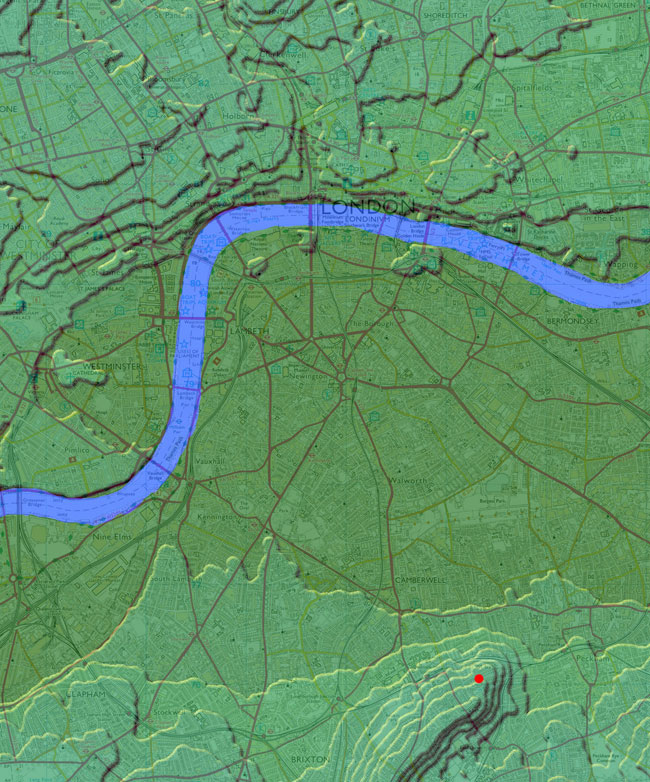
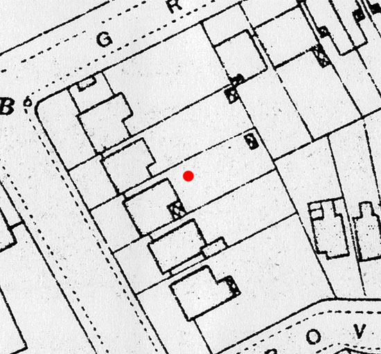
This is the well (the
red dot), in relation to the landscape.
I like to think that whoever did have it built would have used the best dowser
available, after all it has every indication of being deep situated as it
is near the top of a hill. That dowsers were used in ancient times there can
be little doubt, 'dow' is the Ancient British word for water.
It would also seem that from the outset that the waters were considered healing
for they have certainly long had this reputation, so it should come as no
surprise that St Giles is also the patron saint of cripples.
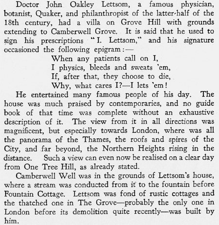
Which brings us to Doctor Lettsom
– now hardly know, but he was rich and famous in his day. He bought
his estate in 1776 which included the well, and it may have been this that
attracted him to the area. He made many improvements to his estate, including
the well, which according to one account is lined with red brick, it is possible
that he had it re-lined, he certainly built many water features, but it is
not clear if the majority of the water he used was from the well or from a
spring on the other side of Grove Lane.
This is his estate
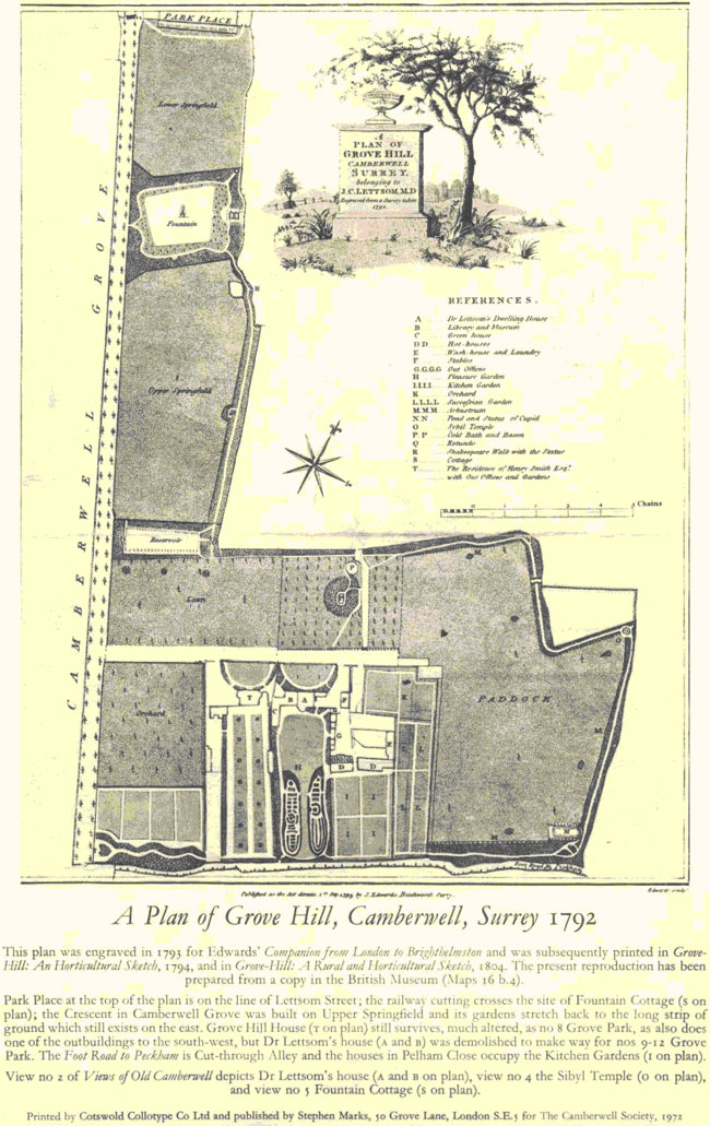
It is quite likely that the donkey driven pump was installed by Lettsom, and he certainly built a cold bath next to the well (marked P on the map above), if not, the other likely time was the early nineteenth century as Camberwell’s population increased.
And it is he who almost certainly had this gate built like the other follies on his estate
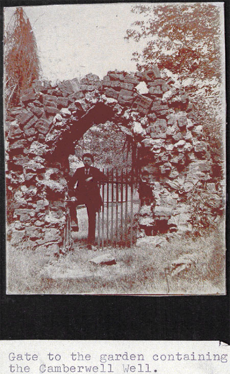
Although it looks old it is probably just a folly built by Lettsom. The top of it is built with over-fired bricks which have become fused together, the lower portion could be older. It is not clear exactly where this gate was but was probably at the north east of the site.
This is the well in a more detailed map of 1868, the thin rectangle
at the end of the path probably represents the gate.
This is the well (centre) in 1830
Here are yet more theories for the name Camberwell from a modern guide by
Mary Boast.
This last theory is not incompatible with Prince Camber –
the Welsh, the Cymry, are supposed to be named after Prince Camber, although
other accounts have Camber being named after the Welsh.
This is from a local history book called ‘Old Camberwell’ it contains other interesting information
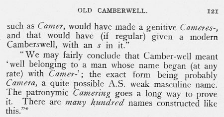
Had the professor known about the Roman coins found in the
well he might have been less likely to ascribe the name to an Anglo-Saxon
source. The Anglo-Saxon culture and language did not arrive in England until
after the Roman period.
This is from another book called ‘The Church under the Hill’
This is from a guide of Camberwell
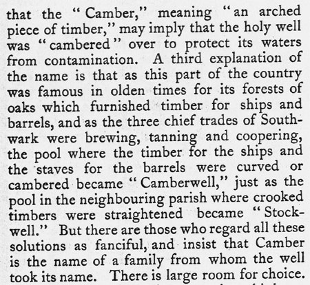
Other contenders for the ‘Camber well’
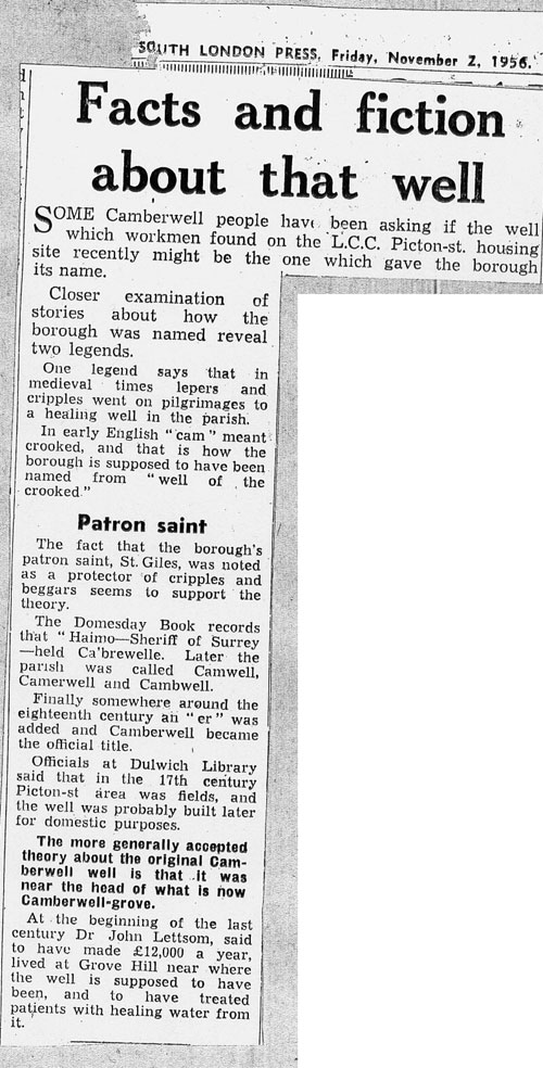
Although several old wells have been found in Camberwell only the one in the garden of 13 Grove Park is a serious contender.
But it is so close
to Lettsom’s wash-house and laundry that it was probably sunk for this
reason.
Although this well exuded water it seems to have soon dried up as this is supposed to be the photo of it.
The number 13 has been added later and it is just possible
that it is actually the original well at number 56 Grove Park and was levelled
off when the garden was divided. The car that was found in the garden, the
remains of a Bentley or Rolls Royce which must have arrived after the building
of the house as both firms were not founded until later.
Here are some other wells
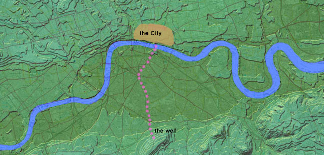
The position of the well
This is likely to be the location of the well shaft
The end of the well
home
| missing Roman road | The
real Troy discovered | pre-Roman London
| Britain's forbidden history | contact
the author