People that have heard about leylines often associate them with mysterious earth energies or think that the lines have supernatural powers but this is unlikely to be the case, leylines are undoubtedly man-made and serve a very practical purpose, they are just another type of road or route and most of the ones I have found are based on early crossing points on the River Thames, a major obstacle to travel in southern England or based on convenient landing points. Another seems to have had a ford over the Thames as its starting point and a gap in the South Downs as the reason it took the course it did. Where its alignment meets the south coast an attempt seems to have been made to make a port but its primary function was the crossing of the Thames and the gap in the Downs, so very practical indeed.
I remain open minded about
earth energies, if they exist then it is possible that they have somehow been
attached to the leylines, also some of the older ones (Stonehenge is supposed
to be on an ancient alignment, for instance) may have been laid out for surveying
reasons, see below, the ancients seemed to already know that the Earth was
round and had measured its circumference with remarkable accuracy.
See
Megalithic
Structures
It was Alfred Watkins who first discovered that there were ancient straight alignments in the landscape and he thought that they were traders' routes and also entirely practical; his book The Old Straight Track is an excellent read. He invented the term leyline or ley line from the frequency of place-names associated with the alignments that end in ley, like Bexley, Bromley, Finchley etc. Properly leylines should be pronounced 'lee' lines, of course, but 'lay' is the accepted version so it is not worth changing it. Watkins described how they were laid out and it would certainly be easy enough to do with ancient technology.
For some reason contemporary archaeologists are deeply hostile to the idea that leylines exist. One exception, possibly the only exception, is the academic and writer Graham Robb who has written The Ancient Paths. As an academic he recognises how controversial he is being, that there are ancient straight lines in the landscape.
He also has this to say -
"For several months, I followed the Heraklean Way and other lines on the map, or rather, scrolled along them repeatedly at what must eventually have been the average speed of a real mouse covering the same itinerary on the ground. Ten years ago, without digital maps and mapping software, this would not have been possible — which is one answer to the obvious question, 'Why has no one thought of this before?'"
Well Alfred Watkins had noticed them! To be fair the lines Robb has found are, he believes, part of a giant 'map' and not traders' routes as Watkins saw them. The book is frustrating for two reasons, he should have given the co-ordinates of his lines so that they can be verified and more importantly perhaps viewed.
Worse than this however is that as an academic he has the typical incredibly low opinion of the capabilities of the Ancient Britons and his knowledge of ancient British history is woeful. Most of the book deals with French ancient history which I hope he has a better grasp of. The French are lucky, their official history does not start with Julius Caesar but goes back a few hundred years earlier and nor are the Gauls depicted as hopelessly ignorant savages.
Robb does something that is unforgivable, he actually deliberately distorts the history, he implies that Caesar had found that Druidism had turned up in Britain after it had crossed the Channel from Europe. What Caesar actually said was the Druidism had been invented in Britain and went further saying that Europeans came to Britain to get the best education in Europe from the Druids.
Anyway, this is an article
I am the middle of writing about a leyline that is so obvious it can be seen
from space. I will be adding maps shortly and other leylines now I have my
old computer up and running again.
The Nunhead Alignment
Some years ago I noticed that there was an obvious straight alignment in the landscape at Nunhead in south east London, a footpath runs over the top of the prominent hill at Nunhead between Nunhead cemetery and a reservoir and this can be readily seen in satellite imagery hence being seen from space. Later I became interested in an area of Camberwell on the borders of Peckham, it doesn't really have a name but the principle road is Southampton Way and it has an ancient feel about it. The Victorian poet Robert Browning of Pied Piper fame had been born here and an ancient and picturesque tavern The Rosemary Branch had once stood here, the tavern's significance will become obvious later.
Google Earth is a very powerful modern tool, and with it I checked the Nunhead alignment. In relatively flat areas like London it is useful to go into the options panel in Google Earth and change the elevation exaggeration to its maximum, x3, which makes hills much more apparent, then using the navigation controls it is possible to tilt and rotate the landscape so that you are looking along the alignment much like looking along a barrel of a gun while aiming it. When I did this it quickly became obvious that part of Southampton Way was on this alignment, this of course may have been a coincidence but further investigation has confirmed that this alignment is real as there are far too many other indications of a straight route for it to be a mere coincidence.
I believe that this alignment is an ancient 'road' or travellers' route that was built when there was an active ford at Westminster and is possibly as old as the Bronze Age. The route started (or finished depending on which way you were travelling) at Stangate in Lambeth which would then have been on the edge of the Thames and presumably marked the south side of the ancient ford which ran just a little to the west of the current Westminster Bridge just in front of the Houses of Parliament, Stangate clearly means 'stone gate'.
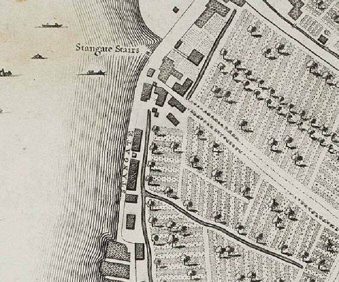
The alignment then passes through 'The Green' which is marked on Rocque's map of 1746, see map below,

which as we shall see is significant for greens or commons occur all along this alignment. There is also an unnamed road that leads from Stangate Stairs that might be part of the route.
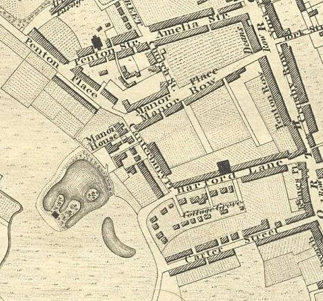
There is no trace of the route until it gets to Walworth where Penton Place (a road) appears to be built approximately along it, although this might be just be a coincidence, but it is almost certainly not a coincidence that where Penton Place crosses Manor Place is the site of where the old Walworth manor house used to be, slightly off-set from the route as if the route had originally determined its position.
Where the route crosses Walworth Road there is an indication of a possible mound for on Greenwood's map of 1827 there is a Mount Street (now Arnside Street) and next to it a group of buildings known as Mount Place, mount being an alternative spelling of mound. Walworth Common (later Walworth Fields) used to adjoin the route here which as we shall see is also unlikely to be a coincidence.
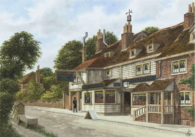
The straight section of Southampton Way between the junction of Commercial Way and the significantly named Peckham Grove appears to be built on the alignment and has certainly been around for some time for it is here that the ancient tavern the Rosemary Branch used to be sited at the junction of Commercial Way and Southampton Way. Several etchings and water colours of it exist and it was a jumble of clearly very old buildings. The tavern used to be popular with Londoners as it was close enough to London for a pleasant day out and presumably why this part of the route developed into a lane.
Although a leyline is a straight alignment between two points it is difficult to work out how stringently they were followed by travellers, possibly in the early days when people travelled on foot with perhaps packhorses, which were good at climbing up and down hills, they were followed quite closely but equally they could have been regarded merely as 'suggested' routes and more sensible routes, for a straight line is unlikely to always give the best route, could have been used instead. A modern example would be a SatNav system, I am not sure how they work but two points are entered and it is likely the computer initially makes a straight line between the two points, the modern equivalent of a leyline, and then checks the data base to see which actual roads are suitable. When the very early leylines like the possible Stonehenge leyline were being laid out it is likely that they did not encounter much existing infrastructure but the leylines in the London area are relatively recent although earlier than Roman and it is clear that a road network already existed.
Southampton Way to the north west of this section leaves the alignment and used to be the central 'spine' of Dolles Common, now built over but remembered in Dowlas Street, but again the old maps show that the southern end of the common was determined by the alignment. For reasons that are not clear this part of Southampton Way is probably a causeway as it appears to have been built up significantly higher than the surrounding land and is presumably man-made rather than natural, it is quite low lying so perhaps it was susceptible to flooding.
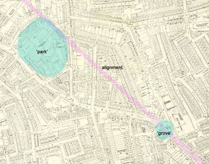
There is another unusual feature here, Parkhouse Street; it curves around for no apparent reason, or so it seems, but on closer inspection there is what appears to be an irregular round structure. It is now an industrial estate but it is clear that the ground is raised here by around two metres, probably artificially, and on the old maps Parkhouse Street is simply Park Street so presumable there was a 'park' here and nearby a 'grove', Peckham Grove, more on this later, the 'park' is just to one side of the alignment.
It is, however, worth reflecting on the landscape here in ancient times, in its virgin state we know from pollen analysis that the higher ground to the south would have been heavily forested, although by the time this route was made it is likely much of the forest would have been cleared for farming. To the north of this point would have been very different indeed – salt marshes. These would have been flat and open as trees cannot live on them and apart from a few small 'islands' the marshes would have continued all the way to Stangate. As there is no significant high ground on the south bank of the Thames at the Westminster ford it would not have made any sense to attempt to cross the marshes at high tide, indeed at an exceptional high tide you would risk drowning as it is thought the entire salt marshes flooded regularly, so any travellers heading towards Westminster and beyond would have been obliged to stay in the Southampton Way area until the tide turned and started going down, and where better to stay than in a tavern.
It is still possible to get some idea of what the salt marshes were like in the London area at Deptford Creek where the Creekside Centre organise walks at low tide. Along the banks of the creek is thick gloopy mud, deposited sediment that is carried up the Thames from the sea when the tide sweeps in, and as you wade through the shallow water of the Ravensbourne river small fish swim around your feet, baby flounders -salt-water fish.
The southern part of Southampton Way is on relatively higher ground yet the road surface is slightly lower than its surroundings suggesting that it has been worn down by use over a long period of time and also showing that it was unlikely to have been paved with stone or gravel like a typical Roman road which is why I have been hesitating calling it a road. It is even more deeply sunk in the final section of Southampton Way, a proper 'country lane' where it leaves the alignment and heads towards the far more ancient Peckham Road which is sited upon the first continuous firm high ground south of the Thames. This road can be traced for long distances on this southern high ground. It passes through Peckham, New Cross, Deptford, Greenwich, Charlton, Woolwich and beyond and I believe has been a proper road since the first farmers settled in the area about 6,000 years ago, they had oxen to pull a plough so they almost certainly had wagons too.
The alignment continues to run up through Peckham although it is not particularly visible but at the junction of the alignment and the ancient Peckham Road on the south side there was another manor house, Basing Manor. This manor house seemed to have faced Peckham Road, the older and more important route, and although the house has long since been demolished it is still remembered by the name Basing Court, now a private car park, however the end this ancient court yard butts pretty snugly against the alignment as if the route determined its position.
It is probably only a coincidence that the alignment runs through Holly Grove and Elm Grove where the route crosses Rye Lane. The route continues to climb through the higher ground but is not visible until it reaches Nunhead and another ancient tavern The Old Nuns Head, rebuilt before the Second World War from a Tudor building, but it now seems likely that there was some kind of inn on this site since antiquity as the taverns seem to be strategically placed to serve travellers using the route.

On old maps there was an alley way behind the pub called May's Place which is likely to be the route. From now on it is fully visible for a considerable distance. As well as having an ancient tavern adjacent to it, it also has a green, Nunhead Green which directly adjoins the route, its original function might have been to allow the travellers' horses to graze, it also would have had an amazing view of the journey ahead, the view is now lost but a similar view can be found near Nunhead overground station and if the tide was still high there might have been time for a few jars of ale before resuming one's journey. The road then continues along Nunhead Grove, another grove place-name, and probably indicates that there was once a grove here.
I have always wondered what a grove is, the usual answer is that they were clearings in forests or woods but that doesn't feel quite right as there were wolves in Britain until the middle ages so any druid would have had to have been constantly vigilant for marauding beasts and even hostile humans, outlaws and the like. I now think the groves were broad mounds in the open and presumably densely planted with oaks (oaks being associated with druids) with maybe a small clearing in the middle, where the druids could meet away from prying eyes. I think I have found a well preserved grove in the Blackheath/Greenwich area, Point Hill is now a park just off Blackheath Hill and on a clear day, in winter before the trees are in leaf, it has a fantastic view over the river Thames and London. It is not entirely natural as three sides of the original hill it stands upon have been cut away and the top flattened to make a kind of hill-fort although it has no sign of earthen ramparts and it may never functioned as a fort as such. Directly under it is a road called Maidenstone Hill, if there was a stone here it is no longer visible, the 'maiden' part of the name might refer to the hilltop where young women (and children?) could spend time in safety or it might even be from the eastern word 'maidan' meaning square or park. On the other side of the road called Point Hill, and nearly opposite the original entrance to the park is a well preserved broad mound with scrubby trees on top. Leading to it and circling around it is Westgrove Lane and it is not hard to imagine the druids keeping a watchful eye on people using the 'park' who would no doubt have been as impressed by the view as we are today, it is much the same view that can be seen from Wolfe's statue in Greenwich Park. It is remarkable how often the place-names park and grove occur together and when they do it is worth taking a close look for very often there will be a 'hill-fort' waiting to be rediscovered.
From Nunhead Grove the route becomes Brockley Footpath which crosses over Nunhead hill between Nunhead Cemetery and the reservoir as seen from satellites. Once there must have been a majestic view but this is now obscured by the cemetery walls, trees, and the raised reservoir, on the southern slope the view is more open as there are allotments on this side of the hill and it is clear that the path is worn down as it is slightly lower than the level of the allotments. Even though the alignment is straight in the landscape at local level is is often far from straight which is another indication that in the past it was not a properly paved road as people would be less likely to wander off a proper road surface if only to keep out of mud in wet weather.
It then becomes Inverton Road, Merttins Road, then Brockley Way which presumably were made into proper roads in the Victorian era. There are two railway cuttings, one of them unusually was a canal before it became a railway, as far as is known no traces of an ancient road surface were found when the cuttings were made. Brockley Way becomes Eddystone Road, however there is a diagonal footpath that crosses Buckthorne Road and here is the most extraordinary alleyway that passes through a Victorian housing development presumably because it has always been an ancient right of way, it is remarkably narrow and far from straight, it then goes through the modern Cypress Gardens where it meets Brockley Road at the side of a large tavern The Brockley Jack.
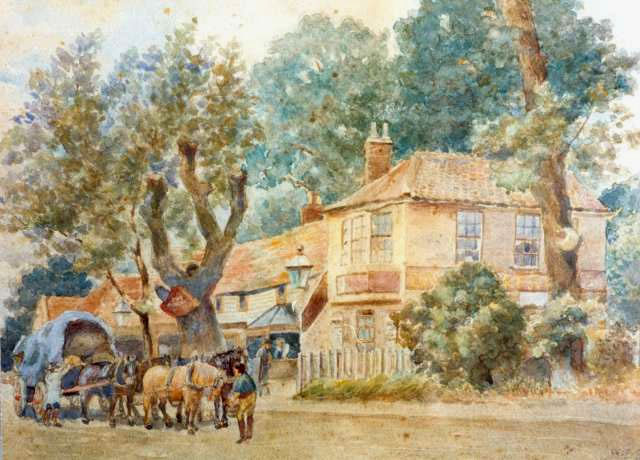
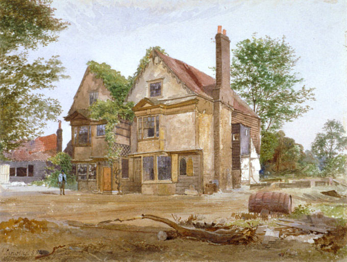
This is another ancient tavern formally known as The Castle and thought to be eighteenth century but is likely to have been far, far earlier than that, in fact, there is every indication that these taverns or inns in some form or other are contemporary with the route, as amazing as that may seem, for the travelers would have needed to be fed and their horses watered. Like the Rosemary Branch a water colour was made of it because it was so picturesque, sadly it was rebuild in 1898. It is gratifying that I knew nothing about the tavern being ancient until I researched it, showing that it didn't influence me in any way.
Next to it was Brockley Green which narrowed to a point at the alignment as if the alignment defined the shape and position of the green. The green is now built over but on the old maps it looks remarkably similar to Dolles Common in that it spreads out on both sides of the central road. Close by and leading to the tavern and green is the road Brockely Grove yet another grove place-name. The route is now lost but it featured as a footpath on an early large scale Ordinance Survey map. I have not yet traced it any further than this but it probably got as far as Catford Bridge where there was another green, Catford Green, if it went any further than this it is hard to say without more investigation but there is certainly nothing as obvious of how it appears in the satellite imagery in the Nunhead area.
A straight line in the landscape like this would usually be considered Roman in origin but there is a very limited opportunity for it to have been made at this period. It seems to be one of a number of roads that fan out from the southern end of the ford at Westminster so it must date from the time the ford was first built or later. A ford over this part of the Thames would have been tidal, that is, it would have been crossable only at low tide. This would have been true two thousand years ago even though the Thames would have been much wider and therefore shallower as it had not yet been embanked, also sea levels were lower than now but it would still have been a difficult crossing as there is no reason to suppose that the flow of water in the Thames was very much different than today. It is likely that the crossing would have been wet, muddy, and dangerous. However the biggest problem would have been the inconvenience, there were usually two low tides a day, at varying times, which meant there would have been many hours of waiting about for the correct time to cross and this may explain why there are the ancient taverns, what better to kill time, or to stay the night if you were too late to make the crossing that day. So when eventually a bridge was built at the London Bridge site and a permanent crossing established it seems almost certain that the Westminster ford would have become immediately redundant. It is usually thought that the Romans built the first London bridge and there is little doubt that the Old Kent Road was built by the Romans to connect to it, this is dated circa 100AD roughly fifty years after the invasion so there isn't much time for the route to have been worn down in the way it has, also if it wasn't paved it is highly unlikely to be Roman for as far as it is known all their roads were paved.
It is instructive to look at the other roads that use the Westminster ford crossing, there is supposed to be a 'mysterious' road that ran in a straight line to New Cross Gate thought by Margary to have been Watling Street but it is probably one of a number of roads that would have fanned out from the ford. Then there is, in my view, the original Watling Street which ran from the ford to another prominent hill, Shooters Hill (and beyond) which has obvious similarities with the Nunhead route. There is also supposed to have been a road that connected the ford at Westminster with the ford at London Bridge. These roads are all likely to have been built before a permanent London bridge and seem to be part of a 'Watling Street' network centred on the ford at Westminster.
There is a section of road that was thought to have been Roman and is a branch of Watling street, it is in a quarry in Shropshire which was about to be extended so archaeologists had a chance to thoroughly examine it before it was demolished. Using a new technique that can date when the road's surface was last exposed to light they were astonished to find that it had been built over a hundred years before the Romans were in Britain. They found something even more extraordinary, that it appeared to have been in use as an unpaved road from the Bronze Age circa 1,500BC when it had been marked out by wooden posts, the expression 'from pillar to post' is probably a distant folk memory from a time when roads were laid out like this, 'off the beaten track' another.
If this road, a branch of Watling street is this old then it follows that Watling Street (as an unpaved road) must also be at least this age and if the Nunhead road is part of the same network then it follows that it must be this kind of age too, and this would explain the grove place-names, pagan not Roman. One last thing that suggests the route is not Roman is the distinctive greens and commons associated with it, had they been made by the Romans they would almost certainly have been either rectangular or square in shape in the Roman manner.
If the route was Roman then no one would question it, straight sections of Roman roads were laid out along straight alignments and were often sighted to prominent hills. But for some reason the Ancient Britons are considered insufficiently sophisticated to have done this themselves even though it is a relatively simple thing to achieve. The Nunhead alignment is so obvious that there can be little doubt that it does exist however as yet it has not been possible to locate it with any precision for two reasons, first is that although it is aligned to Stangate as there are several roads that used the ford and they could have joined up at a point in front of the ford or some other arrangement. Secondly, although the route is aligned to Nunhead hill it doesn't follow that the alignment went to the highest point on the hill there may have been practical reasons, like avoiding difficult terrain, which means that it might be offset. However, although it doesn't seem to have been a proper paved road on the higher ground this is unlikely to have been the case on the salt marshes where some kind of surfacing, probably gravel, would have been required to counter the sticky mud, also there are frequent rivulets and channels in salt marshes which would need to be bridged in some way, the 'mysterious road' from the ford to New Cross Gate was a proper road over the marshes (although not apparently when it reached firm ground) so physical traces of the route might be found some day.
Parks and groves – there may actually be some physical proof in the Southampton Way area for as well as the 'park' at Parkhouse Street there is also the possibility of a 'grove' or broad mound for there is a street called Wells Crescent which is practically a circle and its shape may have been suggested because there was already a circle here and it is opposite the end of Peckham Grove.
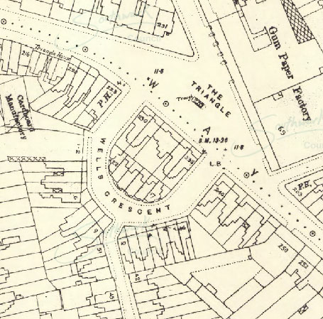
There is a modern estate here now so it is difficult to see if any of the mound remains but Southampton Way is certainly raised at this point. This is the relationship between the possible 'park' and 'grove'.
There is another clear 'park' in the Camberwell area, Grove Park, this is another 'hill-fort' with prominent views towards London and not only is there the grove element in its name and nearby Camberwell Grove, and Grove lane, as well as a large eighteenth century house, Grove House, but it was also a park until it was built upon at the end of the nineteenth century and is the site of the ancient well of Camberwell. This is not connected to the Nunhead alignment, instead it is associated with a very clear alignment from the top of Ludgate Hill which is where St Paul's cathedral is now to a tumulus built on what is the horizon as viewed from Ludgate Hill. This is on a hill called Crowhurst to the south of Croydon and is dated to the Late Bronze Age. The alignment runs down the centre of Camberwell Road which is why you can see St Paul's in the distance if you are traveling north along this road.
Another obvious 'park' is in New Cross, Goldsmith's College is built on it, it is clearly a type of 'hill-fort' and it is just off the ancient road that is a continuation of Peckham Road, this road is very apparent here as it runs along the top of a natural steep cliff caused by the meandering of the Thames back in geological time. There is a Parkfield Street here, all fields had names so presumably the street got its name from a field named after the fact that a 'park' had once been visible here, then there is Laurie Grove. The artificially steepened sides if the 'hill-fort' can best be seen from St Donatts Road where glimpses of the back gardens show that then ends of the gardens are defined by the edge of the 'park', also on Laurie Grove what used to be the swimming pool is built onto the side of a steep slope which can best be appreciated from the alleyway that runs down its side. This 'park' is almost certainly part of the Westminster ford network for if you extend the alignment of the so called 'mysterious Roman road' that runs from the Westminster ford to New Cross Gate it appears to graze the edge of the Goldsmith's 'park' although this part is now a railway cutting so if there was a grove here it is now lost.
Finally, I am reluctant to mention this but if the route is pre-Roman and if unpaved along much of its length then it is a leyline. Anyone who has taken the trouble to read Alfred Watkins' 'The Old Straight Track' will know there is nothing mysterious about them, they were simply practical ways for travelers to move through the countryside and are entirely man-made. They derive their name from the frequency of 'ley's in place-names, Brockley being a good example. He thought they were traders' routes but I doubt if that is quite correct they were probably for all travellers not just traders just like today’s motorways are not just for lorry drivers. He also thought that the incidence of 'white' in place names meant that the routes were used by salt traders but I feel it is far more likely that 'white' and 'red' denoted the equivalent of A roads and B roads the white being the main roads, red the minor roads, and originally painted posts, either white or red, were the early signposts, Red Post Hill, Herne Hill is a good example as is White Post Street which branches off the Old Kent Road. Julius Caesar was presumably referring to this in his 'Commentaries' when he said that there were well-known roads in Britain implying that there were also less known roads.
Perhaps the oddest thing about Alfred Watkins is that he failed to notice that ancient inns and taverns are associated with these straight alignments, had he done so his ideas might have been taken more seriously.
This, I hope, is the Google Earth 'place' of the Nunhead alignment so you can check it out for yourself. On a PC clicking on this link downloads the file which needs to be saved, when opened it should open in Google Earth.
Here are the details of another leyline.
Greenwich Leyline
I have observed that many of the tributaries that meet the Thames are very likely to carry down gravel washed out of the higher ground. This gravel is likely to be deposited on the banks of the Thames a little down stream from the tributary's mouth. This seems to be true at Greenwich and a firm gravelly foreshore would be an ideal place for boats to come ashore.
It is usually thought that the first settlers, the first farmers, arrived in an area in boats and a gravel beach would be an ideal landing point. This is quite likely to have been the case as there is an ancient road that leads straight towards it, Croomes Hill, it was once thought to have been the London area's oldest road probably because, especially towards the top, it has worn down very deeply.
It is very tempting to think that this road was originally hacked out of the undergrowth maybe even under attack from the nomadic hunter gatherers whose land it was, the goal to take the high-ground, now Blackheath and start land clearance.
The road points to a place that presumably was the first 'port' of Greenwich, also pointing directly to it is an ancient alignment or leyline although it is possible that it might have been a road, I have not had a chance to check it out, so it would have been a 'portway' - a way to and from the port.
Below are the components of the Greenwhich leyline. The files are designed to open up in Google Earth although they might open up in other programs. They can also be edited in 'properties'.
A gravel beach ? due to being by the mouth of the river Ravensbourne.
Croomes Hill, an exceptionally ancient road.
medieval church and churchyard.
Brandram Road following the alignment.
Manor Lane following the alignment.
Plaistow Lane section following the alignment.
Holy Trinity church seems to be old.
Hastings Road following the alignment.
Cudham Lane South following the alignment.
The mysterious 'Roman' road
In south London is a fairly well documented 'Roman' road that runs from the
ford at Westminster to New Cross Gate. It is named mysterious for if it were
Roman it ought to connect to the Roman London bridge.
When Julius Caesar conquered Britain he mentioned that there were two fords at London one was at the London Bridge site and the other at Westminster which Caesar said was less heavily defended.
The alignment, initally from the Westminster ford, is a straight gravel road over the salt marshes but it seems to stop at the high ground at New Cross Gate. At the very point that it appears to stop at it is met by the Old Kent Road which is known to be Roman and it seems fairly obvious that it was built as a short cut once the Roman bridge was built.
At New Cross Gate what had previously have been a straight road, marshes are fairly featureless so can be built on anywhere, a straight line is best as it is the most direct.
The road does not stop here, as was once believed, but becomes a road that can be followed throughout Kent to the English Channel at Hythe. Remarkably this road is known for much of its length by its modern designation the A20. This road although frequently meanders from the alignment does rejoin it for time to time perhaps as a reminder that the traveller is on the right course.
The world famous Goldsmiths College is built on a 'hill-fort' associated with the alignment.
Lee Manor House. Lee, the original name for Blackheath Village, is of course a classic leyline name, the manor house appears to have been built on a mound as it is quite elevated.
St Peter and St Paul's Church.
Ridley Church. Given this church's position is on the ridge of a hill it would almost certainly have been seen against the skyline and have been an aid to navigation.
home
| missing Roman road | The
real Troy discovered | pre-Roman London
| Britain's forbidden history | contact
the author